![](/images/other/stat-length.png)
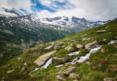
![Randonnée A pied Ceresole Reale - (SI E35) Ceresole Reale (Bregi) - Noasca - Photo](https://media.geolcdn.com/t/1900/400/a5dc36ff-083f-49cd-8ec5-a1c4f1532f3e.jpeg&format=pjpeg&maxdim=2)
(SI E35) Ceresole Reale (Bregi) - Noasca
SityTrail - itinéraires balisés pédestres
Tous les sentiers balisés d’Europe GUIDE+
![Longueur](/images/other/stat-length.png)
Longueur
10,5 km
![Altitude max](https://static1.geolcdn.com/siteimages/upload/files/1508320355ic_sort_altitude_max_24dp.png)
Altitude max
2019 m
![Dénivelé positif](https://static1.geolcdn.com/siteimages/upload/files/1508320355ic_sort_den_pos_24dp.png)
Dénivelé positif
543 m
![Km-Effort](/images/other/stat-length.png)
Km-Effort
19,3 km
![Altitude min](https://static1.geolcdn.com/siteimages/upload/files/1508320355ic_sort_altitude_min_24dp.png)
Altitude min
1059 m
![Dénivelé négatif](https://static1.geolcdn.com/siteimages/upload/files/1508320355ic_sort_den_neg_24dp.png)
Dénivelé négatif
1006 m
![Boucle](https://static1.geolcdn.com/siteimages/upload/files/16400158638029165_repeat_loop_refresh_sync_direction_icon.png)
Boucle
Non
Balise
Date de création :
2022-02-15 13:21:05.162
Dernière modification :
2022-03-01 11:41:01.334
![A pied](https://static1.geolcdn.com/sitytour/trail-icons/100.png)
4h22
Difficulté : Facile
![Scannez ce code QR pour ouvrir la randonnée dans l'application SityTrail](https://capi.geolives.com/qq0zvz2zws4bq2lad0pu/sitytour/trails/3119071/qr.png?size=200)
Application GPS de randonnée GRATUITE
À propos
Randonnée A pied de 10,5 km à découvrir à Piémont, Turin, Ceresole Reale. Cette randonnée est proposée par SityTrail - itinéraires balisés pédestres.
Description
Sentiero Italia CAI 2019
Localisation
Pays :
Italie
Région :
Piémont
Département/Province :
Turin
Commune :
Ceresole Reale
Localité :
Unknown
Départ:(Dec)
Départ:(UTM)
363129 ; 5032328 (32T) N.
Commentaires
Randonnées à proximité
![Randonnée A pied Ceresole Reale - (SI E34V) Villa Poma (Lago di Ceresole) - Rifugio Savoia (Valle d'Aosta) - Photo](https://media.geolcdn.com/t/375/260/a8a7705e-8995-46b0-a00f-d0c62a3e946c.jpeg&format=jpg&maxdim=2)
![A pied A pied](https://static1.geolcdn.com/sitytour/trail-icons/100.png)
(SI E34V) Villa Poma (Lago di Ceresole) - Rifugio Savoia (Valle d'Aosta)
A pied
Très difficile
Ceresole Reale,
Piémont,
Turin,
Italie
![](/images/other/stat-length.png)
23 km | 45 km-effort
10h 8min
![](https://static1.geolcdn.com/siteimages/upload/files/16400158638029165_repeat_loop_refresh_sync_direction_icon.png)
Non
![Randonnée A pied Ceresole Reale - IT-580 - Photo](https://media.geolcdn.com/t/375/260/e182e8f4-511f-4c2d-a30e-f0e1027e4fcd.jpeg&format=jpg&maxdim=2)
![A pied A pied](https://static1.geolcdn.com/sitytour/trail-icons/100.png)
![Randonnée A pied Noasca - IT-552 - Photo](https://media.geolcdn.com/t/375/260/f802ef98-fdee-482d-8018-c53b9cf5df6d.jpeg&format=jpg&maxdim=2)
![A pied A pied](https://static1.geolcdn.com/sitytour/trail-icons/100.png)
![Randonnée A pied Noasca - IT-551 - Photo](https://media.geolcdn.com/t/375/260/ad4c84e0-f3ef-4cf5-9018-b42b1b7b0140.jpeg&format=jpg&maxdim=2)
![A pied A pied](https://static1.geolcdn.com/sitytour/trail-icons/100.png)
![Randonnée A pied Noasca - IT-543 - Photo](https://media.geolcdn.com/t/375/260/be544d6f-9992-4479-9aed-15fddf6a7727.jpeg&format=jpg&maxdim=2)
![A pied A pied](https://static1.geolcdn.com/sitytour/trail-icons/100.png)
![Randonnée A pied Ceresole Reale - IT-542 - Photo](https://media.geolcdn.com/t/375/260/be544d6f-9992-4479-9aed-15fddf6a7727.jpeg&format=jpg&maxdim=2)
![A pied A pied](https://static1.geolcdn.com/sitytour/trail-icons/100.png)
![Randonnée A pied Ceresole Reale - IT-540A - Photo](https://media.geolcdn.com/t/375/260/888ffbf8-6a0b-42a7-b8a5-2ea71ba77980.jpeg&format=jpg&maxdim=2)
![A pied A pied](https://static1.geolcdn.com/sitytour/trail-icons/100.png)
![Randonnée A pied Ceresole Reale - IT-520 - Photo](https://media.geolcdn.com/t/375/260/af307fbb-5b8c-4be1-9f02-51c4006f90b1.jpeg&format=jpg&maxdim=2)
![A pied A pied](https://static1.geolcdn.com/sitytour/trail-icons/100.png)
![Randonnée A pied Ceresole Reale - IT-521 - Photo](https://media.geolcdn.com/t/375/260/269bb00d-8b9c-4d4e-a184-eb56444425d5.jpeg&format=jpg&maxdim=2)
![A pied A pied](https://static1.geolcdn.com/sitytour/trail-icons/100.png)